National Geographic magazine has an unfortunate habit of regularly publishing inaccurate and intemperate articles about Israel, which have falsely blamed Israel for expelling Palestinians, for being responsible for declines in the Arab Christian population (which has actually increased in Israel), for discriminating against Israeli Arabs, and for oppressing Bethlehem. To this list of false accusations the magazine has now added stealing Palestinian and Syrian water, as alleged in Parting the Waters, part of the magazine’s April 2010 Water Issue.
The article, by Don Belt (who wrote the earlier report on the decline of Christian Arabs), is notable for a dubious achievement – there is a deception even before the text of the article actually begins.
The opening picture spread, showing an Israeli couple on the beach of the Sea of Galilee, has a caption that charges “since 1967 Israel has blocked Syria’s access to the lake’s shoreline.”
Technically true, but at the same time extremely deceptive. What Belt doesn’t tell his readers is that Syrian control of the eastern shoreline before 1967 was a violation of both the international border between Israel and Syria, and the 1949 Armistice Agreement between the countries.
According to that international border, set in 1923, the Sea of Galilee was entirely within the Palestine Mandate, and therefore within Israel as the successor to the Mandate. To quote from an article by Frederic Hof (appearing on the very pro-Palestinian Jerusalem Fund site):
The boundary itself was a product of the post-World War I Anglo-French partition of Ottoman Syria. It was demarcated so that all of Lake Tiberias, including a ten-meter wide strip of beach along its northeastern shore, would stay inside Palestine.
Lake Tiberias is another name for the Sea of Galilee, and the border was set in this way because the territory of the Syrian Mandate already had an excellent water supply, including the massive Euphrates River. The Palestine Mandate was not similarly blessed, thus the decision to place in its sovereign territory all of the Galilee and the Jordan River.
When Britain gave up the Palestine Mandate in 1948 and Israel proclaimed its independence, five Arab armies, including Syria’s, immediately invaded, in clear violation of both the United Nations Charter and of UNGA Resolution 181, the so-called Partition Resolution. When the fighting stopped Syrian forces were on the waterline on the east shore of the Galilee. However, in the Armistice Agreement that formalized the end of the fighting, Syria was denied the right to control the Galilee shoreline. Quoting again from the Hof article:
During armistice talks in the spring and summer of 1949, Israel sought the removal of all Syrian forces from Palestine/Israel. Syria demurred, insisting on an armistice line based not on an international border, which Syria insisted did not exist, but on the military status quo.
The result was a compromise. Under the terms of an armistice signed on 20 July 1949, Syrian forces were to withdraw east of the old Palestine-Syria boundary. Israeli forces were to refrain from entering the evacuated areas, which would become a demilitarized zone. In essence, major parts of the armistice line departed from the 1923 boundary and protruded into Palestine/Israel…
The 1923 boundary prevailed as the armistice line in only two places: where it connected the northern and central sectors of the demilitarized zone; and along the ten-meter strip of Lake Tiberias, connecting the central and southern sectors of the demilitarized zone.
It was only because Syria violated the international border and the Armistice Agreement by infringing on the ten-meter strip that Syrian forces had access to the Galilee before 1967.
Unfortunately Belt’s article only got worse once it actually started.
The Jordan River and Israel’s Water Sources
Belt falsely claimed that all of the water of the Jordan river, one of Israel’s key water sources, originate outside of Israel, perhaps wanting readers to believe that Israel is using water belonging to others:
Armed confrontations over the Jordan date to the founding of Israel in 1948 and the recognition that sources of the country’s needed water supply lay outside its borders. Its survival depended on the Jordan River, with its headwaters in Syria and Lebanon, its waters stored in the Sea of Galilee, and the tributaries that flow into it from neighboring countries.
First of all, Israel has three main water sources:
- The Coastal Aquifer, which is entirely within Israel;
- The Western Aquifer, which straddles the border between Israel and the West Bank. Most of the aquifer’s water is stored under Israel, is easily accessible in Israel, and most of the aquifer’s water has always been used in Israel or territory that became Israel before 1967;
- The Sea of Galilee, which is entirely in Israel, and is fed by the Jordan and by underwater springs.
Belt’s claim that the “sources of the [Israel’s] needed water supply lay outside its borders” is thus false, only some of Israel’s water originates in other countries. Belt also failed to inform his readers that this is also true of Israel’s neighbors.
For example, the Euphrates River, one of Syria’s most important water sources, originates in Turkey. Similarly, much of Jordan’s water originates in Syria, and Egypt’s massive (and essentially only) water supply, the Nile River, originates entirely from sources outside of Egypt.
Israel is thus hardly alone in the region in depending on transnational water sources. While Belt does admit this in general, quoting one of his sources as saying “there are few major sources of water that don’t cross one or more political boundaries,” by singling out Israel and not even hinting at the facts about the water sources of Israel’s neighbors, Belt once again deceived his readers.
As for Belt’s reference to the “headwaters” of the Jordan, the largest is the Dan Spring, which is in pre-1967 Israel and is twice as large as the headwaters in Syria and Lebanon mentioned by Belt.
Why, when listing the headwaters of the Jordan, would Belt omit the largest one, which just happens to be entirely in Israel? And why would Belt omit entirely Israel’s other indigenous water sources? Moreover, why would Belt make it seem that the phrase “sources of the country’s needed water supply lay outside its borders” applies onl y to Israel, when the reality is that it applies to all of Israel’s Arab neighbors?
Finally, regarding water supplies in the region, a certain perspective is gained by noting that Syria receives between 3 and 4 billion CM of water annually from the Euphrates alone, significantly more than Israel’s total water supply from all sources of about 1.6 billion CM. (Rivers of Fire, p98, 141).
Who has water parks?
Belt includes in the article this picture of what he says is an Israeli water park in Tiberias:
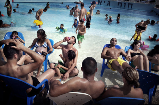
with the following caption (in the print edition):
A source of friction between Israelis and Palestinians, water is emblematic of their unequal relationship. At a water park in Tiberias, Israelis bask in its relative abundance, while Palestinians, restricted to shallow wells by Israel’s occupation, buy West Bank water from Israel with European Union aid.
While Belt doesn’t explicitly say that Palestinians don’t have water parks and Israelis do, the implication is crystal clear. It is also dead wrong, because Palestinians have plenty of their own swimming pools and water parks. Here are some photos of them:
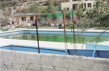 | 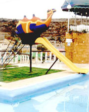 | |
 |  | |
Palestinian swimming pools in the West Bank, which seem never to be noticed by Don Belt and his colleagues at National Geographic. The photo above left is of the Mukhmas Funland amusement park in Ramallah, while the photo above right is a pool in Jenin. | ||
Click here for even more images of the numerous Palestinian swimming pools in the West Bank. Why didn’t Belt or his editors include any of these pictures in the article? Perhaps because telling the truth would have clashed with National Geographic‘s clear agenda. The bottom line is very simple: Belt and National Geographic once again deceived their readers.
Does Israel use Palestinian water, or do Palestinians use Israeli water?
Belt further deceived readers regarding Israeli and Palestinian access to water in the West Bank, including the claim that Israeli wells in the territory “mainly … supply Israeli cities.” In fact none of the water from Israeli wells in the West Bank is piped over the Green Line to supply Israeli cities. On the contrary, water from wells in Israel is piped over the Green Line to supply both Palestinian and Israeli communities in the West Bank. Here are Belt’s claims followed by the facts:
The settlers’ water is provided by Mekorot, Israel’s national water authority, which has drilled 42 deep wells in the West Bank, mainly to supply Israeli cities. (According to a 2009 World Bank report, Israelis use four times as much water per capita as Palestinians, much of it for agriculture. Israel disputes this, arguing that its citizens use only twice as much water and are better at conserving it.) In any case, Israel’s West Bank settlements get enough water to fill their swimming pools, water their lawns, and irrigate miles of fields and greenhouses.
In contrast, West Bank Palestinians, under Israeli military rule, have been largely prevented from digging deep wells of their own, limiting their water access to shallow wells, natural springs, and rainfall that evaporates quickly in the dry desert air.
First of all, in drilling its deep wells in the West Bank Israel was careful to tap into aquifers and strata that were not being used by the Palestinians, so as not to dry up their sources. Israel did this even though such drilling was much more expensive than drilling shallow wells would have been.
As far as use of water, Belt once again deceives by failing to tell readers than much of Israel’s agricultural water is recycled sewage water, which means that when Belt adds it to the fresh water being used by Israelis, he is counting the same water twice. Only by doing so could he claim that Israelis use four times as much water as Palestinians.
One would think that a magazine like National Geographic, which boasts of its environmental coverage, would let readers know that Israel now treats at least 78% of its municipal sewage, about 380 MCM/year, and uses this water for agriculture, thereby saving that same quantity of drinking water (see The Issue of Water between Israel and the Palestinians, page 20)
“Equitable” sharing
Belt also favorably cited an Israeli activist, Gidon Bromberg, of whom he said:
… by challenging his own country to share water equitably, Bromberg has rattled the cages of hard-line Israeli politicians who see water as a national security issue—and as a resource to guard jealously.
In other words, in case the reader still hasn’t gotten it, Israel is not sharing water equitably, most Israeli politicians are hard-liners who apparently live in “cages” otherwise the water would have been shared equitably, and Israelis (or perhaps Jews), rather than sharing valuable commodities, guard them “jealously.”
The real balance of water usage between Israel and the Palestinians
To maintain his theme of Israel’s alleged selfish appropriation of water, Belt keeps from his readers the fact that Israel’s portion of the shared resources, namely the Western and Northeastern Aquifers, has actually decreased since Israel took control of the West Bank in 1967, and the Palestinian portion has increased.
Here are some of the details (for references and citations click here):
Israel obtains roughly 50 percent of its water from the Sea of Galilee and the Coastal Aquifer, both of which are entirely within Israel’s pre-1967 borders. Another 30 percent comes from the Western an d Northeastern Aquifers of the Mountain Aquifer system. These aquifers straddle the Green Line separating Israel from the West Bank, but most of the stored water is under pre-1967 Israel, making it easily accessible only in Israel.
Thus, even in the 1950s Israel used 95 percent of the Western Aquifer’s water, and 82 percent of the Northeastern Aquifer’s water. Today, Israel’s share of these aquifers has declined to 83 percent and 80 percent, respectively. That is, under direct Israeli administration the Palestinian share of these aquifers has actually increased.
In addition, every year over 40 MCM (million cubic meters) of water from sources within Israel is piped over the Green Line for Palestinian use in the West Bank. For example, the major Palestinian city of Ramallah and surrounding Palestinian communities receive over 10 MCM of water from Israel annually, according to the Jerusalem Water Undertaking, the local Palestinian water utility. This accounts for about 83 percent of the water supplied by the utility. (The figure given on the JWU website is an average of 28,000 square meters daily. Aside from the typo of square meters rather than cubic meters, this works out to more than 10 MCM per year.)
And despite the virtual declaration of war against Israel by the Hamas rulers of Gaza, Israel still sends to Gaza another 4 MCM of Israeli water annually through the Kissufim Line of the National Water Carrier, serving the Palestinian localities of El-Bureij, Moazi, Abasan, Bani Suheila and Khan Yunis (Statistical Data on Gaza Area and Jericho, Israel Foreign Ministry, June 1994).
Thus, contrary to Belt, the Palestinians are using Israeli water.
And not just the Palestinians. Despite its own meager supply, Israel annually provided 600,000 CM of water to ten otherwise dry villages in South Lebanon, and provides more than 55 MCM annually to Jordan. Perhaps no other country in the world, facing the severe shortages that Israel does, has shared so much water with its neighbors, including hostile neighbors.
The water of Auja
Belt joined activist Bromberg in visiting the Auja area, in the Jordan Valley near Jericho, and recounted the water shortages that plague the community, while leaving out some key information. Here is Belt’s version of reality:
West Bank Palestinians, under Israeli military rule, have been largely prevented from digging deep wells of their own, limiting their water access to shallow wells, natural springs, and rainfall that evaporates quickly in the dry desert air. When these sources run dry in the summer, Bromberg said, Auja’s Palestinians have no choice but to purchase water from Israel for about a dollar a cubic yard—in effect buying back the water that’s been taken out from under them by Mekorot’s pumps, which also lower the water table and affect Palestinian springs and wells.
As Bromberg and I followed the Auja spring east, we passed a complex of pumps and pipes behind a barbed-wire fence—a Mekorot well, drilled 2,000 feet deep to tap the aquifer. “Blue and white pipes,” Bromberg said. “This is what water theft looks like in this part of the world.”
…when I returned to Auja in early May, its spring had been reduced to a trickle, leaving the village as dry as a fistful of talcum powder. The fields around it lay empty and exhausted …
The facts paint a very different picture. The Auja spring has run dry many times in the past during severe droughts, both before Israel gained control of the West Bank in 1967, and then during Israeli control but before there were any Israeli wells in the area. Thus the spring dried up in July of 1963 during Jordanian rule, for example, and again in 1979. After very heavy rains in 1979/1980 the spring resumed its flow, and at an unusually high rate. (For the details on Auja cited here see Ancient and modern developments of water resources in the Holy Land and the Israel-Arab conflict – a reply, by Zvi D. Y. Ron, Trans. Inst. Br. Geogr, N.S. 11:360-369 (1986))
While there are Israeli wells in the area now, they tap an entirely independent and much deeper aquifer than the Auja spring does, as proven by the different distribution of trace elements in water from the two sources (Ron, p366-367).
There are however, other wells that might be affecting the flow of the Auja Spring, such as this one pictured below:
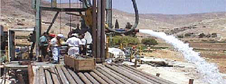
This is Ein Samia Well No. 6, in its final test in 1999, and it is, of course, a Palestinian well. This well and neighboring wells at Ein Samia belong to the Jerusalem Water Undertaking, and are upstream from Auja. While Ein Samia Well No. 6 actually taps into the deeper aquifer also tapped by the Israeli wells, and therefore wouldn’t affect the Auja Spring, two of the JWU’s neighboring wells tap the shallow aquifer that Auja depends on.
It is also interesting to note that the Palestinian JWU has found, in agreement with the Israeli position, that the wells tapping into the deeper aquifer have “no measureable impact” on more shallow wells:
The draw down of water table amounted to 80 m and almost there was no measurable impact on the other existing wells.
The bottom line is that the older, shallow Palestinian wells at Ein Samia send water to Ramallah that otherwise might be available to Auja, and were Ramallah to use less water, Auja would have more water. Unfortunately, readers of National Geographic would have no way of knowing this, since Belt never even hinted at the Palestinian wells, both deep and shallow, at Ein Samia.
Water to the Palestinians generally
There has been a vast increase in domestic (or home) Palestinian water usage in the West Bank since 1967, but this is ignored by Belt and National Geographic, perhaps because informing readers of such facts would undermine the fundamental story line of alleged Israeli oppression.
In the period from 1967 to 1995 West Bank Palestinians increased their domestic water use by 640%, from 5.4 MCM to 40 MCM (Judea-Samaria and the Gaza District – A 16 Year Survey 1967 – 1983, Israel, Ministry of Defense, 1983; Arnon Soffer, The Israeli Palestinian Conflict over Water Resources, Palestine-Israel Journal, Volume 5, No. 1, 1998). By way of comparison, in the same 28 year period Israeli domestic usage increased by just 142% (Statistical Abstract of Israel 1996, V47).
This huge jump in Palestinian consumption was possible o nly because Israel drilled or permitted the drilling of over 50 new wells for the Palestinian population, laid hundreds of kilometers of new water mains and connected hundreds of Palestinian villages and towns to the newly built water system (Background: Water, Israel and the Middle East, Israel Foreign Ministry 1991; Marcia Drezon-Tepler, Contested Waters and the Prospects for Arab-Israeli Peace, Middle Eastern Studies, Vol 30, No. 2, April 1994)
Palestinian sources broadly confirm this picture. For example, Taher Nassereddin, Director General of the West Bank Water Department, has stated that:
[Palestinian] consumption for domestic purposes has increased as a result of population growth and that there were no severe restrictions on drilling new wells for these purposes. (Taher Nassereddin, Legal and Administrative Responsibility of Domestic Water Supply to the Palestinians, in Joint Management of Shared Aquifers, 1997)
It is important to note, however, that for political reasons some Palestinian villages and towns refused to be hooked up to the new water system, and they therefore may not have a reliable water supply today. Thus, as reported in Audubon Magazine, the West Bank town of Marda:
… like many West Bank villages and towns, had refused to hook up with the Israeli water system in the early 1980’s, when Israeli officials offered them the chance. Doing so, the politicians felt, would legitimize the Israeli occupation. (Bruce Stutz, Water and Peace, Audubon, September 1994)
Bananas
Belt’s article features a large two-page picture spread showing workers harvesting bananas on an Israeli kibbutz in the Jordan Valley, with the following caption:
Swaddled against the sun, workers from Thailand harvest bananas on an Israeli kibbutz in the Jordan valley. Though lucrative, the tropical import needs at least eight times as much water as tomatoes. “In a desert, that’s crazy,” says Gidon Bromberg of Friends of the Earth Middle East.
It’s true that bananas require large amounts of water, but it’s also true, and once again omitted by Belt, that Palestinian farmers also grow bananas in the Jordan Valley. In fact, according to the Palestinian Central Bureau of Statistics, total Palestinian production of bananas in 2007/2008 was 5,120 tons, most of it irrigated. And Palestinian production of citrus, which is also extremely water intensive, came in at 62,966 tons, much of it in the water-stressed Gaza Strip (figure includes all kinds of citrus, including Valencia, Shamouty, Navel, etc.).
Has National Geographic ever mentioned to its readers what a vast and unsustainable waste of water such Palestinian agriculture amounts to? Has the magazine ever asked Palestinian farmers or Palestinian officials why Palestinians have largely ignored Israeli innovations such as drip agriculture, which uses far less water by delivering measured amounts of water and nutrients directly to the root zone, thereby avoiding water losses due to evaporation? Have they ever called these Palestinian practices “crazy,” as Belt’s article refers to Israeli agriculture? And to repeat, Belt keeps from readers the fact that Israel, unlike the Palestinians, recycles huge amounts of sewage for use in agriculture, thereby saving drinking water.
The bottom line is that, just as with so many previous National Geographic reports, Belt’s article is simply an extended exercise in bashing Israel, and rather than informing readers instead succeeds only in misleading them.