- 438
- 439SHARES
After the U.N. voted to grant the Palestinians observer state status, Israel announced its intention to move forward with plans for construction in the so-called E1 corridor between Jerusalem and Ma’aleh Adumim.
Ever since, news stories and opinion articles about the Israeli decision deluged the public with dire claims: The E1 corridor will bisect the West Bank. It will block access to Jerusalem from Palestinian cities. It will prevent establishment of a viable and contiguous Palestinian state. It will destroy all chances of a two-state solution to the Palestinian-Israeli conflict.
The reporting echoes hyperbole by political activists like Danny Seidemann, who has described the plan as the “doomsday weapon” and “fatal heart attack of the two-state solution” because, he claims, “the West Bank will be divided into two and the two-state solution will be impossible.”
According to the Society of Professional Journalists, reporters are expected to “test the accuracy of information from all sources.” This is especially true when citing such extreme claims. Readers depend on journalists to do more than just regurgitate partisan sound bytes. They rely on them to challenge, probe, and ask questions.
But instead of exhibiting a journalist’s skepticism, too many reporters accepted false allegations about the E1 corridor as truth, without asking the most fundamental questions of “how” and “why.” The Economist stated that building in the area “would bisect the West Bank’s northern and southern halves.”Agence France Press unquestioningly reported that experts believe E1 construction “would isolate Arab east Jerusalem and cut the West Bank in two.” And The New York Times stated as fact that E1 would “divid[e] the West Bank in two” and make a Palestinian state “virtually impossible.”
(After CAMERA staff discussed the issues with editors at the New York Times, the newspaper published corrections noting that E1 development would not completely separate [Palestinian] cities from Jerusalem,” “would not divide the West Bank in two,” and “would not, technically, make a contiguous Palestinian state impossible.”)
1. The Contiguity Charge
Palestinian contiguity in the West Bank would not be cut off with construction in the E-1 corridor. The American Heritage Dictionary defines contiguous as continuous without a break or a continuous connection. Regarding Israel and the West Bank, the concept and interpretation of contiguity is best understood by examining a map of the area.
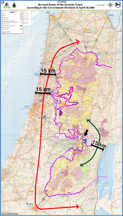
On the above map, an arrow points to a blue mark indicating the rough location of the proposed E1 corridor between Jerusalem and Maaleh Adumim. This corridor sits within the proposed route of the security barrier encircling Ma’aleh Adumim and Jerusalem, indicated with a pink and purple line. The purple line shows the section of the security barrier that is already built and the pink line shows the section not yet built and subject to revision. The construction of homes would take place in a small subsection of E1.
The green line indicates a route between northern and southern West Bank cities that lies outside E1 and the territory that might be encompassed by the proposed security barrier. Those who charge that Israeli building west of Ma’aleh Adumim severs north-south contiguity disregard the fact that the northern and southern parts of the West Bank are connected by land east of Ma’aleh Adumim (marked on the map) that is at its narrowest point also about 15 km wide.

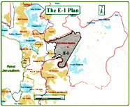
Close up of E-1 within possible route of security barrier.
The construction of Israeli homes in the E1 area does not mean roads there would necessarily be shut to Palestinian traffic, or that other direct routes could not be provided. One such direct route for Palestinians has already been constructed and could be opened for traffic if security concerns require a change to current traffic patterns. Indeed, buried at the very end of one New York Times article where allegations about West Bank bisection and a non-contiguous Palestinian state predominated, there was a description of such a road, ready to be put into use whenever needed:
A few miles away in E1, there is already such a road, built in 2007, its lanes divided by a concrete wall designed to look like Jerusalem stone. One side is meant for Israelis, and would have exits to Maale Adumim and various parts of Jerusalem. The other, for Palestinians, would have few off ramps but provide a path from Ramallah to Bethlehem to answer criticism about contiguity. (“Dividing the West Bank, And Deepening a Rift,” Dec. 2, 2012)
Moreover, if the E1 corridor is not built, the Israeli town of Ma’aleh Adumim — which almost all agree will be annexed (including previous peace negotiators) — would become an island, without a land bridge to the rest of Israel. To Israel’s critics, however, such contiguity for Israel is unnecessary and undesirable.
Under a final agreement, neither Israel nor a Palestinian state would need to be inconvenienced by longer, more circuitous drives between cities. Both could have direct access to their cities under roads and access agreements decided upon by both parties.
2. Palestinians Not Cut Off From Eastern Jerusalem
Palestinian access to Jerusalem is not contingent on the E1 corridor. That small area lies to the east of Jerusalem. There are other more direct ways to access the city, subject to final status agreement on Jerusalem. Bethlehem, for example, is south of the city and Ramallah is north. Travelers from both cities would be taking a more circuitous route were they to access Jerusalem through the E1 corridor.
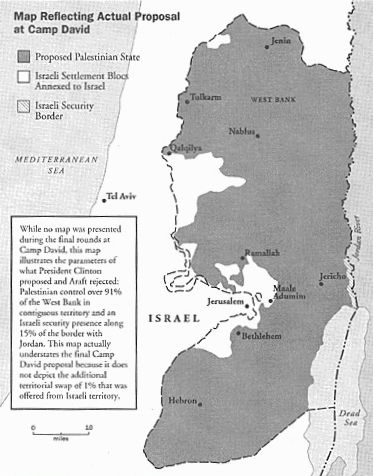
3. Previous Peace Negotiations
The map clearly shows the E-1 area under Israeli control and a contiguous Palestinian state in the West Bank.
In short, all the hysteria about the E-1 corridor bisecting the West Bank, preventing access to Jerusalem, and destroying the possibility of a viable and contiguous Palestinian state is simply not true. And it demonstrates
a double standard in what is considered “contiguity” for Palestinians and for Israelis. Were Israel to return to its pre-1967 boundaries, as most critics of Israel’s E-1 plan advocate, the country would be no more contiguous than the West Bank: Before 1967, southern and northern Israel were connected by a long strip of land that was about 15 km at its narrow points. While Israel’s critics view this as acceptable contiguity for a viable, Jewish state, they consider it unacceptable for Palestinians.
While development of E-1 might not fulfil every Palestinian demand about the contours of its future state, and while it might have an impact on the two side’s conflicting claims on Jerusalem, it certainly does not prevent a contiguous Palestinian state, and it certainly does not prevent a viable Palestinian state.


