
In a June 9, 2026, analysis entitled, “Why Lebanon may hold the key to the future of the Iran war,” CNN reporter Jeremy Diamond included a fundamentally flawed dataset that erases the experiences of thousands of Israeli citizens.
The graph tracked air, drone, and artillery strikes between Hezbollah and the Israel Defense Forces (IDF) from Oct. 8, 2023, to June 12, 2026. However, a quiet disclaimer beneath the graph reveals a glaring omission: “Does not include events outside of Israel or Lebanon, such as strikes in Israel-occupied Golan Heights.”
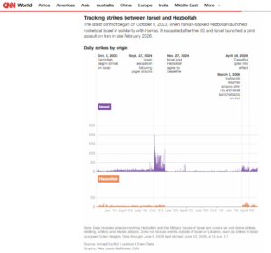
Screenshot of the misleading graph CNN used to illustrate strikes between Israel and Hezbollah.
By deliberately excluding Hezbollah strikes in the Golan Heights, CNN’s data visualization departs from the reality on the ground, minimizing Hezbollah’s aggression and misrepresenting the scope of the war. Even if CNN defends this as a neutral geographic filter, excluding IDF strikes in Syria alongside Hezbollah strikes in the Golan, it creates a false equivalence. When the IDF has struck within Syria in the context of fighting Hezbollah, it was interdicting weapons and infrastructure in a third-party country. When Hezbollah strikes the Golan Heights, it is attacking territory governed by Israel, populated by Israeli citizens, and defended by the IDF. Treating both simply as “events in Syria” distorts the reality of the war.
The decision to carve the Golan out of the dataset hides the deadliest single Hezbollah attack on civilians of the entire conflict: the July 2024 rocket strike on the Druze town of Majdal Shams that killed 12 children.
Hezbollah fired rockets, missiles, and drones at the Golan Heights as part of its mission to eradicate Israel. The terrorist organization was not aiming for Syria. By excluding this region, CNN omitted massive volumes of Hezbollah fire.
Misusing ‘Gold Standard’ Data
CNN sourced its numbers from the Armed Conflict Location & Event Data Project (ACLED). In the realm of conflict tracking, ACLED is widely considered the gold standard, providing data on global conflict and civil unrest.
As an international NGO, ACLED utilizes strict geographic and legal frameworks to categorize its data, often mirroring the United Nations. In ACLED’s system, the Golan Heights is coded as the Quneitra province in Syria (though many legal scholars argue the territory is legally Israeli). “Palestine” is coded as a state comprising the West Bank and the Gaza Strip (though it does not meet criteria for statehood). ACLED’s reliance on funding from U.N. bodies like the Complex Risk Analytics Fund (CRAF’d), which has provided the organization with $14.8 million, helps explain its adherence to these specific international designations.
While this methodological rigidity may serve an international database, it becomes a dangerous political filter when adopted uncritically by news outlets. CNN justifies its exclusion by classifying the Golan Heights as occupied Syrian territory. However, Israel has governed the territory since 1967 and annexed it in 1981, a sovereignty the United States formally recognized in 2019, and which the succeeding Biden administration never reversed, making the policy bipartisan.
By categorizing strikes on the Golan Heights as events in occupied Syria, CNN implicitly frames Hezbollah as a resistance force fighting for Syrian territory. Hezbollah, though, cannot pose as a protector of Syrian interests given its active role in the mass slaughter of civilians during the Syrian civil war.
Worse, CNN erased the people who live there. The territory is home to over 50,000 residents, including tens of thousands of Jewish Israelis and over 26,000 Druze.
Following the Majdal Shams attack and the subsequent ousting of Bashar al-Assad in Syria in December 2024, naturalization of the Druze in the Israeli Golan Heights skyrocketed. In 2024, 570 Druze became Israeli citizens; in 2025, that number jumped to 3,750; and, by February 2026, Israel had naturalized another 873 as citizens. Today, over two-thirds of the Golan Heights population holds Israeli citizenship.
Notably, after Hezbollah’s deadly strike on Majdal Shams, it was the Israeli government and civil society that rehabilitated the town, not Syria. Yet, by CNN’s math, their collective value is zero.
Even using ACLED’s own data, the scale of the omission is significant: ACLED recorded 514 Hezbollah projectiles that hit populated areas or landed in open fields in the Golan Heights between October 2023 and December 2025. Tzofar, Israel’s rocket alert application, recorded at least 439 siren incidents in the Golan due to Hezbollah rocket and drone fire between October 2023 and June 2026. (This conservatively excludes sirens during the recent 2026 Iran war, when attributing specific projectiles to Hezbollah versus Iran was difficult).
Flattening Hezbollah’s terror
Hezbollah flag flying over an abandoned artillery piece on the grounds of the former South Lebanon Army prison in Khiam, January 2, 2007. Illustrative. (credit: Paul Keller via Flickr, CC BY-NC 2.0)
With few clear data points, CNN’s graph presents a skewed illustration of the war. Because Israeli action in Lebanon clearly outnumbers Hezbollah’s actions against Israel in CNN’s selective data, the graph flattens the reality of Hezbollah’s terror.
Moreover, since the graph narrowly limits itself to kinetic strikes, the report conveniently ignores the IDF’s documentation of 1,925 ceasefire infractions in 2025, such as rearming, refusing to disarm, maintaining military infrastructure south of the Litani River, and constructing underground tunnel networks. Even within its own limited parameters, CNN still fails its own terms by excluding actual rocket fire on universally recognized territory in northern Israel, beyond the Golan Heights.
On March 22, 2025, and March 28, 2025, rocket fire from Lebanon forced several Israeli communities in the Upper Galilee region to shelter once again, despite the ongoing ceasefire. Although Hezbollah denied that it fired the rockets and the exact perpetrators remain unknown, the group maintains strict control over southern Lebanon. The launch site was within its geographical responsibility.
ACLED noted in an April 2025 overview, “Hezbollah denied responsibility, hinting at another faction within its sphere of influence.” [Emphasis added]
CNN’s graph includes Israel’s retaliation but excludes the very rocket attacks that provoked it. This reveals a blind spot in modern data journalism. Since Hezbollah denied responsibility for the attacks, ACLED likely logged the actor as an “unknown.” CNN’s skewed filtering isolated the data for “Hezbollah” without accounting for the group’s use of proxies in southern Lebanon, enabling a terrorist organization’s public denials to dictate the reality shown on their graph.
Issues with viewing data as objective
CNN’s use of ACLED data reflects a broader issue in modern newsrooms: relying on NGOs for information without interrogating their limitations, methodologies, and biases. Readers view a clean, authoritative graph, completely unaware of the partisan geographical and political coding operating beneath the surface.
While ACLED’s raw data is unparalleled, its written analyses frequently assume Israeli malice, such as accusing the IDF of purposefully targeting medical staff in “double-tap” strikes or intentionally targeting the Lebanese Armed Forces. While massive datasets offer journalists a convenient way to visualize conflicts, placing two warring parties side-by-side overlooks a major blind spot. Every battle zone possesses unique political, organizational, and geographic characteristics that prevent data from being collected with equal accuracy. When journalists equate these mismatched datasets, they mislead their audiences by treating an apples-to-oranges comparison as objective reality.
For the Hebrew version of this post, see CAMERA Hebrew.