
In response to communication from CAMERA, CNN merely cosmetically altered its August 20, 2026, report, “Israel moves forward with internationally condemned settlement plan that could ‘bury’ two-state solution,” while leaving its false premise completely intact.
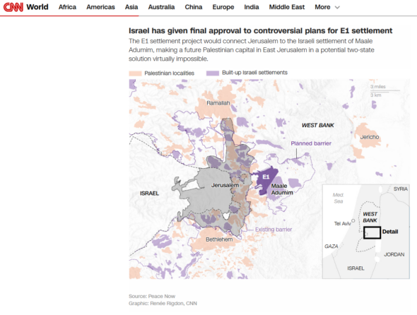
Screenshot of CNN’s map, sourced from Peace Now. The map shows Jerusalem, E1, Ma’ale Adumim, the surrounding planned barrier, and other surrounding cities and towns.
In the article, Tal Shalev, Zeena Saifi, and Oren Liebermann reported on Israel’s Housing Ministry inviting bids to construct over 1,200 housing units in E1, a strategic corridor that borders Jerusalem and covers an area of 12 sq. km. (12,000 dunams or 4.6 sq. mi.). Building up this area would connect the existing built-up settlement of Ma’ale Adumim directly to Jerusalem’s Mt. Scopus.
Highlighting a choir of international condemnation, CNN originally asserted as fact that the E1 settlement plan would “divide the West Bank into north and south, making a continuous Palestinian state impossible.” Following CAMERA’s critique, CNN altered the text to read that E1 would “effectively divide the West Bank… making a contiguous Palestinian state virtually impossible.” [Emphasis added].
Still, adding qualifiers does not change the existing status or boundaries within the region.
First, E1 is situated within Ma’ale Adumim’s municipal boundaries in Area C, territory placed under full Israeli civil and security administration pursuant to the 1990s Oslo Accords, a series of bilateral agreements that both Israel and the Palestinian Authority signed. These agreements divided the West Bank into Area A (full Palestinian control), Area B (Palestinian civil and joint security control), and Area C.
Crucially, both the Israelis and Palestinians agreed that the permanent status of settlements and Area C itself would be resolved in final-status negotiations, acknowledging the settlements in Area C are not illegal by definition and establishing Area C as disputed territory.
Oslo II in 1995 included a provision to gradually transfer Area C to Palestinian jurisdiction after five years, pending permanent status negotiations. All attempts at these permanent status negotiations have failed for a variety of debatable reasons.
Yet while CNN quoted the Israeli advocacy group Peace Now, which argued that building on E1 was part of Israel’s “scorched-earth policy … to secure long years of conflict and bloodshed for Israel,” the network ignored the Palestinian Authority’s explicit strategy to establish infrastructure throughout Area C to forge de facto contiguity without any negotiations. By treating Area C as inherently sovereign Palestinian land, CNN adopts a biased framework that ignores both the text of the Oslo Accords and the dual-sided nature of the dispute.
The proposed construction in no way changes the fact that this Israeli-controlled block already sits between Palestinian-controlled territories to the north and south. Furthermore, to the east of the planned security barrier sits mostly open land in Area C surrounding Jericho (in Area A). As CAMERA’s Ricki Hollander and Gilead Ini detailed in 2012, those who charge that Israeli building west of Ma’ale Adumim severs north-south contiguity disregard that land east of Ma’ale Adumim connects the northern and southern parts of the West Bank, that is, at its narrowest point, about 15 km (9.32 mi) wide.
A recent CNN article claimed Israel’s E1 plan would “divide the West Bank into north and south, making a contiguous Palestinian state impossible.”
The geographical reality? Even @CNN‘s own map—sourced from Peace Now—shows an unblocked ~15 km land corridor east of Ma’ale Adumim… pic.twitter.com/VZNdUKVK3l
— CAMERA (@CAMERA4Truth) August 27, 2026
This argument that construction in a 12 sq. km. piece of land is the nail in the coffin for a continuous Palestinian state ignores that previous two-state solution proposals (such as the 2000 Clinton Parameters) included E1 within Israel (according to U.S. chief negotiator Dennis Ross’s book The Missing Peace). This proposal still maintained a contiguous Palestinian state, demonstrating that contiguity in this region is a subject of negotiation and design, not an absolute geographical impossibility. Furthermore, the Gaza Strip as part of a future independent Palestinian state would also mean that this Palestinian state would not be contiguous. Regardless, contiguity is not even a legal requirement for statehood, and a multitude of non-contiguous states exist.
Peer publications have recognized that E1’s impact on contiguity is a matter of debate. In 2012, The New York Times corrected similar claims about the effects of Israeli construction in the E1 corridor.
CNN also omitted infrastructure projects that would reconnect Palestinian cities in Area A by road, misleading readers into assuming Israel is intentionally physically severing north-south transit.
While E1 and the security barrier would cut off the existing road that connects Ramallah and Jericho (in the north) to Bethlehem (in the south), Israel is already constructing a bypass road that would connect Ramallah to Bethlehem.
Furthermore, Israel’s Security Cabinet has also pledged to allocate NIS 10 million for planning a road that would connect Bethlehem to Jericho, known as the “Road 80 Substitute”. Together, these routes would preserve Palestinian vehicular transit between the north and south.
In response to CAMERA’s request for correction, CNN attempted to justify its reporting by pointing to politics. The network argued that Finance Minister Bezalel Smotrich has explicitly stated his intent to use E1 to “bury” the possibility of a Palestinian state. But professional journalism must distinguish political posturing from physical facts on the ground, especially for an outlet that claims to report “facts first.”
Declarations of political ambitions, whether from Bezalel Smotrich pledging to block a Palestinian state or the Palestinian Authority (PA) pledging to unilaterally assume control of Area C in disregard of the Oslo Accords, do not alter reality.
News networks can quote outraged ambassadors, highlight controversial politicians, and strategically insert adverbs to soften their structural errors. But when it comes to claims of “impossible” borders and severed territories, the map never lies.